

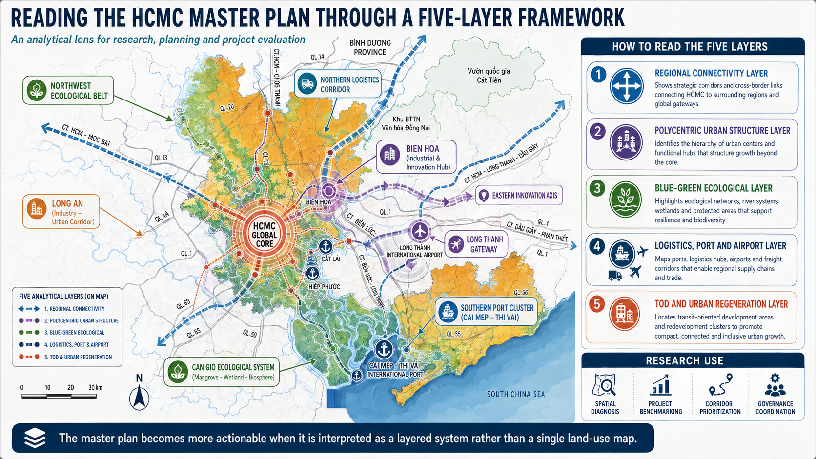

Figure 1. Reading the HCMC master plan through a five-layer framework. OasisConcept analytical redraw on the HCMC master-plan base map supplied by the client. The five layers are regional connectivity, polycentric economic structure, blue–green ecology, logistics/port/airport systems, and TOD/urban regeneration. Not a statutory planning map.
Abstract
This Urban Insight asks a practical research question: how can the administrative consolidation of Ho Chi Minh City, Bình Dương and Bà Rịa–Vũng Tàu be translated into measurable metropolitan performance rather than territorial scale alone? The proposed answer is a five-layer framework that treats the mega-urban region as an interacting system of (1) territorial ecology, (2) functional specialization and economic structure, (3) connectivity and accessibility, (4) governance–finance–delivery, and (5) place, equity and identity. The framework is grounded in the July 2026 HCMC master-planning working draft and UAH–HIDS conference materials, and tested against international empirical research on agglomeration, polycentricity, accessibility and metropolitan governance. The literature does not support polycentricity as an unconditional optimum; instead, its economic effects depend on density, scale, functional specialization, integration and governance. The framework therefore converts a normative spatial vision into propositions and indicators that can be evaluated with metropolitan data and used in project practice.
1. Research problem: administrative consolidation does not automatically create functional integration
The HCMC working draft describes a metropolitan territory of approximately 6,772.6 km² and 14.4 million residents and proposes a Polycentric Hyper City structured through five growth poles, five strategic linkage systems and ten development-management regions. These are important spatial hypotheses, but they are not yet evidence of functional integration. A scientifically useful framework must distinguish the map of intended structure from the measurable performance of the system.
The starting hypothesis is therefore H0: territorial scale alone does not predict metropolitan performance. The alternative hypothesis is that performance depends on the interaction among effective economic density, accessibility, specialization, ecological capacity and coordination. This position is consistent with agglomeration research: city size and density can increase productivity, but the magnitude varies by sector and context (Melo, Graham & Noland, 2009), while governance fragmentation and congestion can erode those gains (Graham, 2007; Ahrend et al., 2017).

Figure 2. HCMC master-plan structure interpreted as a metropolitan economic system. OasisConcept analytical redraw on the supplied HCMC master-plan base map. The figure is used as the spatial reference for the five-layer research framework.
2. What the evidence says before a planning model is chosen
A rigorous urban framework should begin with areas of agreement and areas of uncertainty in the literature. The evidence on agglomeration is relatively strong: larger accessible economic mass is generally associated with higher productivity, though elasticities vary across contexts. The evidence on polycentricity is materially less settled. This distinction matters because a planning strategy should be built around robust mechanisms and treat contested relationships as propositions to test rather than assumptions to repeat.
|
Evidence question |
What the literature indicates |
Implication for HCMC |
|
Does agglomeration raise productivity? |
Generally yes, but magnitude varies by sector, country and measurement. Meta-analysis: 729 estimates from 34 studies (Melo et al., 2009). |
Seek effective economic mass, but do not transplant foreign elasticities directly. |
|
Is polycentricity always more productive? |
No. Positive, negative and conditional effects are reported (Zhang et al., 2017; Li et al., 2019; Li & Liu, 2018; Wang et al., 2019). |
Treat polycentricity as a conditional spatial strategy, not a universal optimum. |
|
Does integration between centres matter? |
Yes. Urban-network literature emphasizes functional integration, complementarity and borrowed size (Hall & Pain, 2006; Meijers & Burger, 2010; Meijers et al., 2018). |
Measure actual flows among poles, not only the existence of multiple centres. |
|
Does accessibility matter more than geometric distance? |
Transport-based accessibility to economic mass is associated with productivity; effects decay with travel time (Graham, 2007; Melo et al., 2017). |
Use travel-time and opportunity measures to evaluate corridors and TOD. |
|
Does governance affect productivity? |
Yes. Fragmentation is associated with lower productivity; metropolitan governance mitigates the penalty (Ahrend et al., 2017). |
Align governance with functional labour, freight, water and ecological systems. |
3. Layer 1 — Territory and ecological capacity
Layer 1 asks what the metropolitan territory can physically and ecologically support before development intensity is allocated. The HCMC planning materials describe a high–low–sea structure and a blue–green network organized around the Sài Gòn, Đồng Nai, Nhà Bè, Soài Rạp and Thị Vải systems, Hồ Dầu Tiếng, the Cần Giờ mangrove biosphere reserve and coastal ecological areas. These systems affect flood storage, water security, heat, biodiversity and infrastructure reliability; therefore they must be treated as constraints and productive assets, not post-design landscape.
For research, the layer should be quantified using flood depth and duration, drainage basin, groundwater and subsidence risk, surface temperature, green–blue connectivity, ecological value, water-storage capacity and climate exposure. The planning proposition is explicit: development intensity should be conditional on ecological carrying capacity rather than assigned independently and mitigated later.

Figure 3. Blue–green strategic structure in the HCMC master plan. Source base: HCMC Total Master Planning working draft, July 2026; clean analytical presentation by OasisConcept. The map is used as the spatial evidence base for Layer 1.
4. Layer 2 — Functional specialization and the conditional logic of polycentricity
Layer 2 is where the framework departs most clearly from a purely morphological reading of the city. Polycentricity is not measured by counting coloured circles on a map. It requires the identification of centres, their relative size, their economic specialization, and the flows that connect them. Hall and Pain (2006) emphasize functional relationships within polycentric metropolitan regions; Meijers and Burger (2010) examine the possibility that cities can share or borrow agglomeration advantages.
The empirical literature requires caution. Zhang, Sun and Li (2017) find a positive association between polycentricity and labour productivity in Chinese city-proper data; Li, Sun and Zhang (2019) find stronger productivity in more monocentric prefectures; and Li and Liu (2018) show a density-dependent effect in which high-density cities are more likely to benefit from polycentricity. Wang, Derudder and Liu (2019) find that intra-urban monocentricity and inter-urban polycentricity can jointly support productivity. The research implication is therefore conditional: HCMC should test whether proposed secondary poles are dense enough, specialized enough and connected enough to generate network benefits without dissipating the agglomeration economies of the core.

Figure 4. Morphological versus functional polycentricity. OasisConcept analytical diagram based on the urban-structure literature. The research task is to measure flows and complementarity, not only spatial form.
5. Layer 3 — Connectivity, accessibility and effective economic density
Layer 3 converts infrastructure from an inventory into a performance system. The OECD–EU Functional Urban Area definition is useful precisely because it follows commuting flows beyond municipal boundaries. For HCMC, equivalent analysis should include passenger accessibility, freight accessibility, airport and port access, and knowledge-network connectivity.
The evidence supports using accessibility rather than distance as the key variable. Melo et al. (2017) estimate agglomeration elasticities of about 0.07–0.10 for large US metropolitan areas and report that most productivity gains occur within the first 20 minutes of employment accessibility. Graham (2007) similarly links transport-induced changes in access to economic mass with wider productivity benefits. These estimates are not Vietnamese calibration values; they demonstrate the mechanism that should be tested locally.
The HCMC 15/30/60-minute concepts can therefore be reformulated as nested accessibility indicators. At 15 minutes, the metric is access to daily services; at 30 minutes, access to major employment and knowledge nodes; at 60 minutes, access to the regional airport–port–industry–innovation system. Each band should be measured by reachable opportunities, not by a geometrically drawn radius.

Figure 5. Nested accessibility as a measurable metropolitan-performance concept. OasisConcept synthesis. The 15/30/60-minute bands should ultimately be generated from multimodal network data rather than Euclidean distance.
6. Layer 4 — Governance, finance and delivery
Spatial integration fails if infrastructure, land use, housing, ecology and economic development are optimized by separate institutions. Ahrend et al. (2017) find that greater governance fragmentation is associated with lower city productivity; doubling the number of municipalities is associated with an estimated 3–6% productivity penalty, and the existence of a metropolitan governance body reduces that penalty by about half. The magnitude is comparable to the productivity premium associated with city size.
For HCMC, Layer 4 should distinguish internal and external coordination. Internally, the master-planning working draft’s ten development-management regions offer a possible functional layer between metropolitan strategy and local implementation. Externally, Long Thành airport, Đồng Nai industry, Tây Ninh / Mộc Bài, interregional rail, river basins and coastal systems require coordination outside the city boundary. Governance performance should therefore be measured through project-alignment time, shared capital programming, data interoperability, cross-boundary service standards, land-value capture and the proportion of infrastructure investment coordinated across sectors.

Figure 6. Dual-linkage governance model. OasisConcept analytical diagram connecting internal metropolitan delivery with external functional-region coordination.
7. Layer 5 — Place, equity and identity
The fifth layer prevents functional integration from becoming spatial homogenization. The metropolitan system includes the historic Sài Gòn–Chợ Lớn core, industrial landscapes of Bình Dương, the Cần Giờ mangrove system, port landscapes around Cái Mép–Thị Vải, and the coastal tourism geographies of Vũng Tàu–Long Hải–Hồ Tràm. Their value lies partly in difference. Planning should therefore evaluate whether regional integration preserves place-specific climate responses, cultural morphology and public life.
Equity belongs in the same layer because accessibility and land-value uplift are unevenly distributed. TOD, infrastructure and regeneration can increase access while also increasing displacement risk. Practical indicators should include affordable housing within high-access zones, jobs reachable by low-income households, public-space provision, relocation burden, and the share of land-value uplift reinvested in local infrastructure and social services.
8. Five testable propositions for the HCMC mega-urban region
|
Proposition |
Mechanism |
Suggested indicators / test |
|
P1. Accessibility to economic mass is more predictive of productivity than administrative scale. |
Sharing, matching and learning increase with reachable economic opportunities. |
Travel-time weighted jobs; supplier access; university/R&D access; wage or value-added per worker. |
|
P2. Polycentricity improves performance only under sufficient density, specialization and integration. |
Secondary centres must retain agglomeration benefits while reducing diseconomies. |
Centre density; employment specialization; inter-centre flows; complementarity index; labour productivity. |
|
P3. Transport investment produces larger economic effects when it connects complementary functions. |
Reduced travel time changes effective density and market size. |
Before/after generalized travel time; reachable employment; freight reliability; changes in firm productivity. |
|
P4. Governance fragmentation reduces metropolitan productivity unless coordination capacity compensates. |
Uncoordinated land use and infrastructure increase transaction and congestion costs. |
Number of agencies/jurisdictions per project; approval time; shared budgets; cross-boundary governance arrangements. |
|
P5. Ecological-capacity-led development reduces long-run system risk. |
Avoided flood, heat and infrastructure externalities protect economic continuity. |
Expected annual flood loss; heat exposure; storage capacity; green-blue connectivity; infrastructure downtime. |

Figure 7. Research propositions that can be tested with metropolitan data. OasisConcept conceptual diagram. Propositions P1–P4 are directly anchored in the cited urban-economics and governance literature; P5 is presented as a planning hypothesis to be tested for the HCMC ecological context.
9. Application protocol: how a project team should use the framework
The framework is designed to be used before form-making. A project team should first locate the site within the metropolitan system and identify which ecological basin, economic node, transport catchment and governance territory it belongs to. Second, the team should define the project’s primary metropolitan function and test whether it complements or duplicates existing centres. Third, it should model accessibility before and after the intervention. Fourth, it should identify ecological constraints and infrastructure dependencies. Fifth, it should specify the delivery mechanism, including cross-agency responsibilities, financing and value capture. Only after these steps should built form, density and phasing be optimized.
|
Stage |
Required output |
Decision gate |
|
1. Territorial diagnosis |
Ecology / hazard / basin map + regional position |
Can the site safely carry the intended intensity? |
|
2. Functional role |
Specialization and value-chain map |
Does the project add a distinctive metropolitan function? |
|
3. Accessibility |
15/30/60-minute multimodal accessibility model |
Does it increase reachable opportunity and reduce critical travel time? |
|
4. Cross-layer integration |
Land use + mobility + ecology + housing + utilities matrix |
Are sectoral plans mutually reinforcing? |
|
5. Delivery & value |
Governance, phasing, funding and value-capture plan |
Is implementation capacity commensurate with the spatial ambition? |
10. Limitations
This framework is a research and decision-support structure, not an empirical proof that a particular HCMC spatial configuration is optimal. Several relationships are endogenous: productive places attract infrastructure and skilled workers, while infrastructure and workers can also raise productivity. Polycentricity is scale-dependent and measurement-dependent. Foreign elasticity estimates cannot be transferred directly to HCMC. The July 2026 master-planning material is a working draft, and several proposed nodes and corridors remain planning hypotheses. For these reasons, the framework should be used to define a metropolitan data programme and to test alternative spatial scenarios rather than to validate a predetermined plan.
Conclusion
The principal contribution of the five-layer framework is methodological. It replaces a single master-plan image with a set of relationships that can be measured, contested and improved. Urban form is linked to productivity through agglomeration and accessibility; polycentricity is treated as conditional on density and functional integration; infrastructure is evaluated by access to economic mass; governance is treated as a measurable productivity variable; and ecology and equity define whether growth remains viable over time. This is the level at which a short Urban Insight can remain practical without abandoning scientific discipline.
For OasisConcept, the design implication is equally important: a project should not begin with the question of what can be built on a site. It should begin with the question of what metropolitan relationship the project is supposed to improve—and how that improvement will be measured.
R&D OasisConcept
Source base for HCMC-specific statements
TS.KTS. Lê Quốc Hùng, Từ đô thị cực lớn đến vùng kinh tế lớn: Đề xuất một mô hình không gian - quản trị mới cho siêu đô thị TP.HCM trong kỷ nguyên tăng trưởng quốc gia (From Megacity to Mega-Economic Region: Proposing a New Spatial-Governance Model for the Ho Chi Minh City Megacity in the Era of National Growth); UAH–HIDS Conference Proceedings, Shaping the Spatial Structure of the Ho Chi Minh City Mega-Urban Area in a New Context, July 2026. HCMC-specific concepts are cited at proceedings / institutional level in this website edition.
HCMC Total Master Planning 2025–2050, 100-year vision: Overall Orientation and Technical Infrastructure Planning Report, working draft for the HCMC task force, July 2026.


